About Alignment Viewer
[LEGACY VERSION - NO LONGER UPDATED] Save time with Alignment Viewer – Import a rail or road alignment and receive real-time chainage / station and offset position information. Designed to assist highway and railway...
[LEGACY VERSION - NO LONGER UPDATED]
Save time with Alignment Viewer – Import a rail or road alignment and receive real-time chainage / station and offset position information.
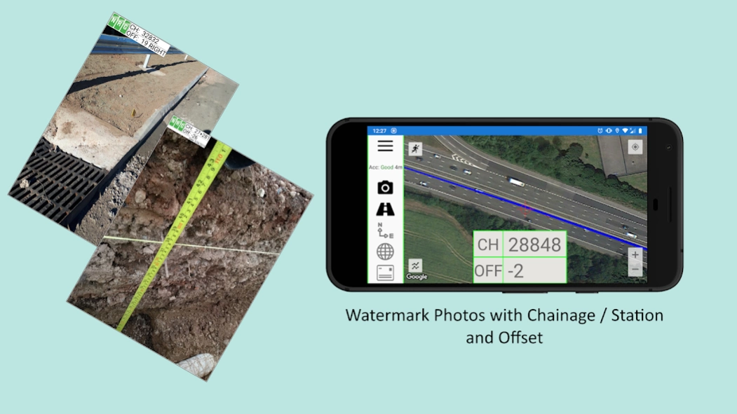
Designed to assist highway and railway construction / maintenance perform quick and easy site inspections to identify and report on site issues and progress from the field. Photos watermarked with chainage / station and offset ensure reports are prompt, accurate, and BIM compliant making this the perfect app for the modern Civil Engineer.
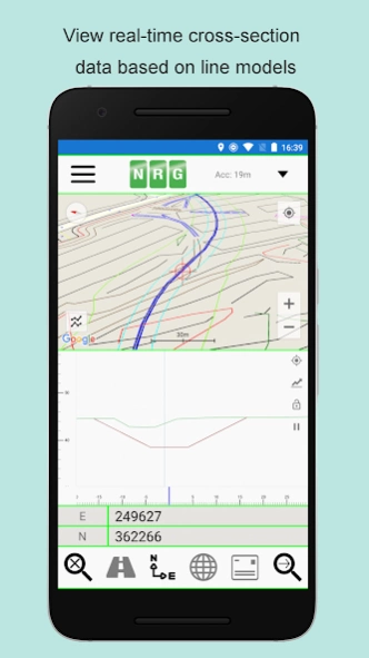
Import and view geometric lines, points and explore cross sections drawn from provided design and ground level data. Convert between geodetic WGS84/ETRS89 world coordinates (Latitude Longitude) and Cartesian Easting Northing based on thousands of available grid transformations with an optional site shift and scale factor.
****Alignment Viewer Features****
Please find below the full list of features provided by Alignment Viewer:
**Road / Rail Alignments**
Import alignments from LandXML (.xml), or NRG Alignment format (.nst).
Provides support for road and rail alignments incorporating Curves, Spirals, Clothoids, Parabolas, and Straights.
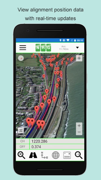
Real-time position updates in Chainage / Station and Offset.
Take photos watermark with Chainage / Station and Offset.
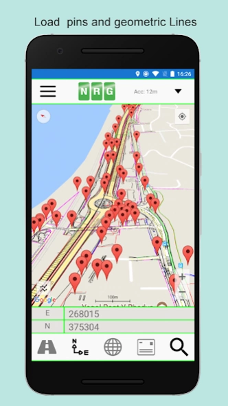
**Geometric Pins / Points**
Allows the import of pins from Google Earth files (.kml), NRG Ground Plot Files (.gpf) and ASCII/CSV files (.txt).
Pins can be manually placed based on geodetic, Cartesian or geometric alignment coordinates.
Allows for editing of imported pins.
Allows for the export of new pin files (.kml, .gpf, or .txt).
**Geometric Lines**
Lines can be imported from Google Earth files (.kml).
Lines can be loaded to the map, loaded to the cross section or loaded to both.
Cross section display color can be selected for each line file.
Provides support for loading multiple line files at once.
**Watermarked Photos**
Photos can be taken which will then be watermarked with the Chainage / Station and Offset of the current location.
**Cross sections**
Allows the creation of a cross section perpendicular to a given geometric alignment or heading.
Cross section updates in real-time.
Cross section mode supports pausing updates, locking scale / transformation and importing Google ground elevation data.
**Landscape mode**
Perfect for placing on your vehicle dashboard NRG Alignment Viewer landscape mode provides clear and real-time updates to the device position in terms of WGS84, Cartesian EN and Geometric Alignment (Chainage/Station/Meterage) coordinates.
****Configuration Options****
Alignment Viewer provides an extensive list of configuration options allowing the app to be tailored to your preference.
**Geometric Alignment Configuration Options**
Offset display formation: -/+ or Left/Right.
Alignment distance: Chainage/Station/Meterage.
Alignment format 10000/10+000/100+00
Decimal places display for Alignment/EN.
**Map Configuration Options**
Traffic display.
Street, Satellite, and Hybrid map types.
Cross-hair.
Map scale bar.
Units of measurements: Imperial/Metric.
**Cross Section Configuration Options**
Cross section centre: Mid-Point or User defined Offset.
User defined scale section / Cross section distance.
Vertical Exaggeration.
Google Elevation segment distance
Enable / Disable Scale bars.
**Watermarked Photo Configuration Options**
Watermark position
Watermark size
Show road / rail alignment name
Show gps accuracy
Show date
Show time
**Manual**
NRG Alignment Viewer manual can be found at http://www.nrgsurveys.co.uk/downloads/alignmentviewer.pdf
It is strongly recommended that new users view the manual to make full use of the NRG Alignment Viewer.
Tags: GPS, Road Alignment, Rail Alignment, WGS84, ETRS89, OSGB36, Civil Engineering, Highway Maintenance, Surveying, Cross section, Road Construction, Chainage, Station.
Previous Versions
Here you can find the changelog of Alignment Viewer since it was posted on our website on 2019-07-02 12:41:14.
The latest version is 3.02 and it was updated on 2024-04-22 13:16:14. See below the changes in each version.
Alignment Viewer version 3.02
Updated At: 2021-08-06
Changes: Fixed issue with reloading ASCII pins.
Alignment Viewer version 3.01
Updated At: 2021-03-05
Changes: **Reminder: New project file location. Manual can be found at https://www.nrgsurveys.co.uk/downloads/alignmentviewer.pd**
*Small bug fix in 3.01*
Images now accessible via Gallery/Photos again.
Alignment Viewer version 3.0
Updated At: 2021-03-01
Changes: Added support for new file path required for Android 11 .
Images will now need to be accessed via this route rather than phone's Gallery/Photos app.
Existing project data will still be in the old directory, however it will need to be migrated to the new file path in order for the app to access the data.
New file path for projects and images.
"[YourDevice]Internal sharedstorageAndroiddatacom.nrgsurveys.alignmentViewerfiles".
***Uninstalling app will now delete projects and images***
Alignment Viewer version 2.9991
Updated At: 2021-02-24
Changes: Added "Register Details" & "Privacy Policy" buttons
Added Location Data Disclosure
Fixed file storage access error for Android 11+ devices
Alignment Viewer version 2.999
Updated At: 2019-10-02
Changes: Added the ability to create new projects within the application.
Added the option to import LandXML directly from the device / connected cloud services.
Alignment Viewer version 2.998
Updated At: 2019-09-09
Changes: Fixed an issue where the current position was not displaying correctly on the cross section.
Alignment Viewer version 2.995
Updated At: 2019-06-12
Changes: Added a setting for Transformation units. This setting will determine the unit of measurement used to display transformed coordinates.
Added a setting for Accuracy Threshold which will determine what the app considers to be Good / Poor position accuracy.
Added a warning before taking a photo when position accuracy is poor.